
Kordil Deformation Monitoring System – Low Cost and High Accuracy
Kordil H4 GNSS System
March–May 2016
RTK GNSS monitoring of a building during metro construction: field application, March–May 2016
Work Carried Out by: Kordil Mühendislik Sanayi ve Ticaret Limited Şirketi
INTRODUCTION
The building to be monitored is located on the E5 service road in Pendik, where metro construction was already in progress. The client requested a study to determine possible horizontal and vertical deformation associated with the metro works. In response, Kordil Mühendislik Sanayi ve Ticaret Limited Şirketi (Kordil) completed the work using the methods described in this report.
This report describes the method and data processing used in 2016. A fixed-ambiguity RTK solution (FIX), or averaging over a long period, does not by itself establish millimetre accuracy; the reference frame, multipath, antenna stability and measurement uncertainty must also be considered.
METHODS AND SYSTEMS USED
Deformation Survey Method
The favourable location of the building allowed deformation measurements to be made using the satellite-based İSKİ UKBS network. A GNSS receiver capable of receiving corrections from this network was first installed on the roof. A computer and Kordil Navigation Pro – Deformation Edition software were then integrated to record and monitor the receiver data in real time.
The software also recorded data from the GNSS/GPS system, which continuously received internet corrections and operated in FIX mode with centimetre-level precision. These records were used to prepare weekly summary deformation reports. The summary table, collected raw data and technical brochures for the instruments and systems were provided as appendices to this report.
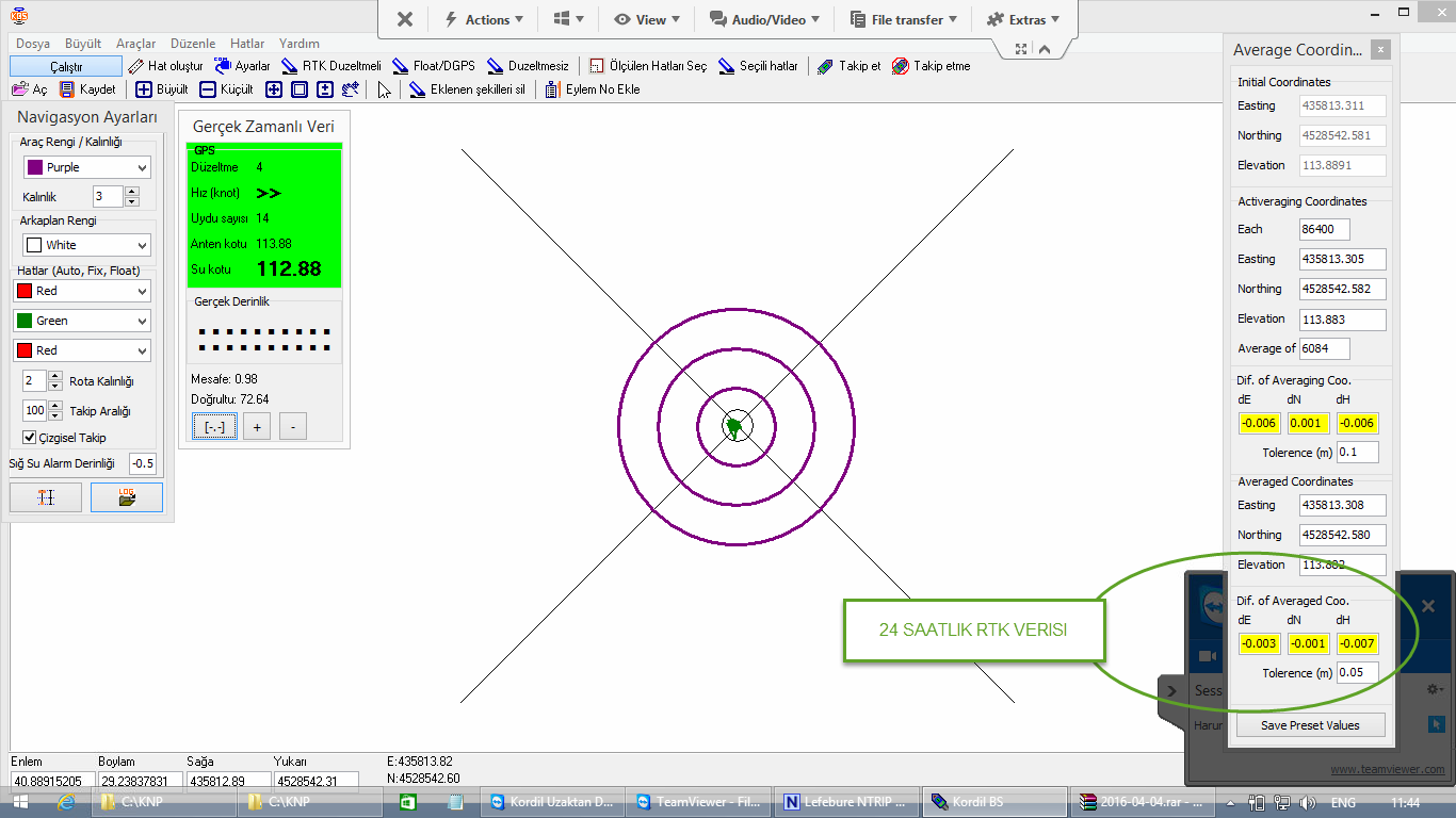
Screenshot from the measurement computer integrated into the system. The green field at the upper left indicates a FIX GNSS position solution. On the right is the real-time results display. It shows the differences between reference coordinates, taken as the average of the first two days, and coordinates derived from the latest 24 hours of data. Values outside the tolerances shown on this screen were excluded to remove gross errors.
SURVEY AND DATA PROCESSING
GNSS data recorded throughout the monitoring period were processed weekly, and the resulting comparisons were checked before publication. Kordil's proprietary advanced filtering and weighted averaging methods were used in the data processing.
The processed position data for the latest 24 hours were averaged and compared with the reference coordinates to examine horizontal and vertical movements. The table below summarises the findings over the two-month period.
|
Date |
Day |
Coordinate Differences (m) |
||
|
dE |
dN |
dH |
||
|
2016-03-17 |
1 |
0.000 |
0.000 |
0.000 |
|
2016-03-17 |
1 |
0.000 |
0.000 |
-0.001 |
|
2016-03-18 |
2 |
0.001 |
0.001 |
0.002 |
|
2016-03-21 |
5 |
0.000 |
0.000 |
0.000 |
|
2016-03-26 |
10 |
0.000 |
0.001 |
-0.012 |
|
2016-04-05 |
20 |
-0.001 |
0.000 |
-0.017 |
|
2016-04-08 |
23 |
-0.002 |
-0.002 |
-0.004 |
|
2016-04-10 |
25 |
-0.003 |
-0.002 |
-0.010 |
|
2016-04-18 |
33 |
-0.003 |
-0.003 |
-0.007 |
|
2016-04-24 |
39 |
-0.002 |
-0.002 |
-0.013 |
|
2016-05-02 |
47 |
-0.002 |
0.000 |
-0.004 |
|
2016-05-09 |
54 |
-0.002 |
-0.002 |
-0.011 |
|
2016-05-15 |
60 |
-0.002 |
-0.002 |
-0.013 |
The table lists coordinate differences over the sixty-day monitoring period. To interpret these differences as structural deformation, measurement uncertainty, antenna and roof-mount stability, temperature effects and independent check measurements must be assessed together. This table alone cannot establish that movement was caused by metro construction or that the building is safe.
The original report concluded that no significant metro-related movement had been observed. This is a field interpretation for that particular period and must not be used as a current assessment of structural safety.
Request a Quote for Your Deformation Monitoring Project
Share your requirements for a similar deformation monitoring application.
Request a Quote