
AcadTRK Open-Source Lisp Package (for AutoCAD, GStarCAD and BricsCAD)
Version 2
AcadTRK Open-Source Lisp Package (for AutoCAD, GStarCAD and BricsCAD)
AcadTRK is a set of AutoLISP tools designed to simplify surveying and drawing tasks. It performs coordinate exchange, setting out, elevation annotation, profile work and area calculations within the CAD environment. Available commands and compatibility depend on the CAD product, version and AutoLISP support; check the tools on a copy before using them on production drawings.
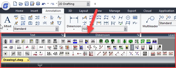
General Tools

Map Symbols

Surveying Tools

Writing to and Reading from Files

Menu

AcadTRK
Development of AcadTRK began in 1992, and new commands were added to meet field and office needs. The descriptions on this page introduce the software's history and archived tools; they should not be taken as a commitment to current-version support or ongoing maintenance.
Load the source files, menus and commands in the archived package in a way appropriate to your CAD environment. Operation in older versions does not guarantee full compatibility with current or different CAD products.
The Kordil AcadTRK package is free of charge.
Edit Tools

Map Symbology

Drawing Tools

File Tools

Pull-down Menu

DESCRIPTIONS
FILE
convertxyz: Converts coordinates into a readable ID, X, Y, Z format in the file “c:\ Kordil_AcadTRK_Dec_08_INPUT.csv”.
loadcoordinates: Writes the converted point as text at the insertion point. During coordinate insertion, prompts ask whether point numbers and elevations should also be added.
coordinatesout: Writes the ID, X, Y, Z information for the clicked point to “Kordil_AcadTRK_for_OUTPUT.csv” without overwriting.
settingout: Adds setting-out values to a file using distances and angles for two stations.
EDITING TOOLS (COMMANDS)
mapscale: A fundamental setting affecting all programs. Assigns a map scale based on the line scale so that objects have visible, practical sizes.
rollback: Restores the defaults created by AcadTRK. It can be reloaded automatically when required.
autobilipmode: Mouse turns marker blips on or off
flatten: Sets the elevations of selected objects to zero.
makelayer: Creates and names a layer, then makes it the current layer.
kordillayers: Creates predefined layers embedded in the Lisp code, which must be edited as necessary. Users can change the layer names.
movetoactivelayer: Moves selected objects to the current layer.
movetoaspecifiedlayer: Moves selected objects to another layer identified by selected objects.
changetobylayer: Changes selected objects to ByLayer properties.
changetobylayer: Changes selected objects within blocks to ByLayer properties.
areacalculation: Calculates the area defined by selected points and displays it on screen. It uses rounded decimal values, currently set to eight places. The command was written to avoid small discrepancies caused by rounded values in manual area calculations, particularly for cadastral parcels.
idpoint: Coordinate query
distance: Returns the distance and azimuth between two specified points in gon and degrees (degrees, minutes and seconds).
cleanlayer_id: Deletes the ID labels of points imported with the file tools. Warning: deletes all content on the automatically created ID layer.
cleanlayer_el: Deletes elevation labels for points imported with the file tools. Warning: deletes all content on the automatically created EL layer.
cleanlayer_po: Deletes point markers imported with the file tools. Warning: deletes all content on the automatically created PO layer.
cleanacadtrklayers: Deletes all content on the three layers above (ID, EL and PO) created when ID, X, Y, Z points are imported.
DRAWING TOOLS
angleline: Creates a new line at an angle in a specified direction.
writeelevation: Labels the elevation of the clicked point.
kothesap: Derives a point elevation using the average of three specified points.
assignnumber: A numbering tool for labelling points sequentially on screen.
basayaziekle: Adds a string at the start of a text label.
sonayaziekle: Adds a string at the end of a text label.
writecoordinates: Labels the coordinates of a point on screen as shown by the icons.
Writecoordinates2: Labels the coordinates of a point on screen as shown by the icons.
Writecoordinates3: Labels the coordinates of a point on screen as shown by the icons.
writeeasting: Labels grid eastings.
writenorthing: Labels grid northings.
writeeastingnorthing: Labels grid eastings and northings.
writecoordinastotetable: Writes the coordinates of clicked points into a table.
writedimofedge: Labels the distance between two specified points.
writedistanceazimuthdms: Labels distance and azimuth in DMS along a line or between two points.
writedistanceazimuth: Labels distance and azimuth in gon along a line or between two points.
baseline: Labels distances along a line from its start to clicked points.
baseline2: Labels distances at the start and end points of a line.
kroki1: Labels the chainage and offset of a point relative to a line, with labels placed at the midpoint of the line.
korki2: Labels the chainage and offset of a point relative to a line, with labels placed at a specified location near the line.
parcellplan: Creates a parcel plan and labels the coordinates of its vertices and its area.
profile1: Adds offsets and elevations to a profile. Useful for creating tabulated sections from existing profiles. Horizontal and vertical scales can be set in the code. The default scale is 1:1.
profile2: Labels elevations and offsets below and above the profile line.
profile3: Labels elevations and offsets on an extended line.
profile4: Labels elevations above the profile line.